Seamus Cullen’s Personal Web Site
Featuring Local History from North Kildare
The Drummin Road
The Drummin road is an ancient name for the road in Moortown that extends from Moortown junction close to the ‘Old Rathcoffey Hall’ to Painstown Cross-roads.1 The name comes from the Irish Druimín or Dromainn which means a small ridge.2
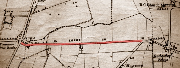
Map showing Drummin Road
The road crosses two small hillocks, which are not easily identifiable in the landscape. The two small hill were formed naturally on the shore of an ancient lake in the northern portion of the townland of Moortown. From the early medieval period the Moortown ridge began to be used as a route-way, and eventually a road was constructed along the route-way that linked Rathcoffey with Donadea. It is noticeable that the land drops off sharply on either side of the road. The road is therefore elevated and is approximately two to three meters above the surrounding landscape.
The first map that the road appears on is Noble and Keenan’s map from 1752. Alexander Taylor’s map from 1783 shows the road in more detail and extending across a slightly raised area. The first O.S. map from 1837 shows the field system and other landscape features alongside the road.
A stile in a wall on the north side of the road is a reminder of times past when path-ways were used by pedestrians as a shortcut through the fields to either the local school or the Chapel.
The road in recent times has undergone a revolutionary transition. In the early 1960s there were three thatched dwellings alongside the road, the residences of the Keeffe, Walsh and O’Neill families. Today the road is one of the most heavily populated roads in the district with a new housing estate Moortown Drive and continuous houses extending almost entirely on the south side of the road. The most recent major development on the road is the new extensive Rathcoffey GAA Centre. This ambitious project caters for the needs of a one of the fastest growing rural communities in the county.
- The name of the road was first given to the author by the late Dolly Moore in 2001
- The term drumlin as a geological term applied to those small hills in the ‘Drumlin Belt’ that extends across Ireland from County Down to County Mayo. In the present article the term as used by locals is purely descriptive and, unlike the ‘real’ drumlins, is made up of mostly glacial gravels.