Seamus Cullen’s Personal Web Site
Featuring Local History from North Kildare
The History of Rathcoffey
First published as ‘The Civil parish of Balraheen’ in Oughterany, 1995
Rathcoffey is in the civil Parish of Balraheen which is situated in North Kildare approximately half way between Kilcock and Clane. There are eight townlands in the parish and apart from Rathcoffey the others are Bareen, Baltracey, Clonduff, Clonfert, Graiguepottle, Painstown and Raheen. The parish has an area of 3,372 acres and with the exception of Rathcoffey Hill the land is flat and arable. It is drained by the Lyreen River and its tributary streams.
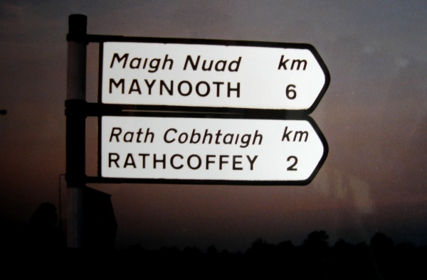
Sign post at Boherhole cross
The earliest archaeological evidence within the area dates from the late ‘Ice Age’. Numerous bones and antlers of the ‘Great Irish Deer’ otherwise known as the ‘Irish Elk’ were found first in 1896 and later in 1945.1 The site of these discoveries was at the shore of a prehistoric lake which existed in the area south of Rathcoffey Hill.
The name Balraheen comes from the Irish Baile-Raheen which means settlement of the little rath. Two adjoining place names Raheen and Bareen derive their names from this source. The only trace of ring forts or raths in any of these townlands is the site of a ring barrow in Raheen and the name almost certainly comes from this field structure. The ring barrow consisted of two small mounds with an enclosing ditch and bank four yards in diameter around both of them. The area within these circles was used for cremated burials in the Bronze and early Iron age. This structure was in existence up until the early 1980s.
The patron saint of the civil parish is St Mochua who lived in the sixth and seventh centuries. This saint also called Cronan was a disciple of St Kevin and an Abbot of Clondalkin monastery. He evangelised much of North Kildare, built a Church at Celbridge and travelled regularly to Timahoe where he had a house. Balraheen is halfway between these two places and the fact that this parish is dedicated to him would suggest he built its first Church. With a small Christian community or settlement emerging close to this church the area was then called Baile-Raheen (Balraheen).
The Celts from this period lived in tuathas or tribal homelands. The Ikeathy tribe having moved up from Central Kildare took control of the area between the Rye at Kilcock and the Liffey at Clane. The landowning class of this tribe lived in ring-forts called Raths. Some of these structures are still identifiable and can be located throughout the Rathcoffey area. The outline of one such ring fort is visible at Clonfert. All that remains is a semi-circular ditch with a slight slope completing the circle. This structure could have been associated with Fiacra Goll of Cluain Fert near Kilcock who is mentioned in eighth century genealogies.2 Another ring fort is situated at Clonduff close to the Pale. The larger part which is in one field has traces of a circular ditch while the smaller section in an adjoining field consists of a semi-circular raised area almost two feet high.
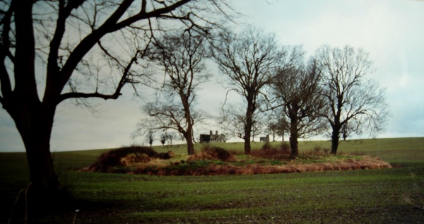
Celtic ring-fort at Rathcoffey
Close to Baltracey Bridge on a small hillock is the site of another such dwelling. This ring fort was almost certainly moated, i.e. ring ditches filled with water from the nearby river. The fact that present day water flow proceeds through high ground instead of around the hill would confirm this fact. The best preserved and largest ring fort is at Rathcoffey and is situated close to the Straffan road. This earthwork was also moated as it is sited on the banks of the Lyreen River. A sixth century hostel was situated in this area and is mentioned in the Book of Leinster. The hostel, ‘Teach Coffey MacColman’ was situated on the main highway between the Kingdom of Meath and Leinster3 and was probably the structure which gave the townland its name. These ring forts would have changed hands regularly over the centuries and by the ninth century the Ui Faoilan tribe controlled the area.
The tribal was taken over by the Normans in 1171 and the Celtic landholders gradually expelled. A barony was created out of the older Celtic tribal division of Ikeaty and this area came under the control of John de Hereford. At the conquest the usual procedure was followed. An area around a church which was at that time developing into a parish was created into a manor. In this way the manor of Rathcoffey was created with probably the same boundaries at the parish of Balraheen. At this stage of the conquest the lowest class of the Irish remained on as serfs to their new masters. Settlers were brought in and obtained divisions of land in size to present day townlands. These farms were called Graigues or Granges and one of the townlands Graiguepottle probably retains the name of its original Norman settler Pottle.
The manor of Rathcoffey passed out of the Hereford family ownership following the marriage of Eve de Hereford and Walter de Rochford in the 1200 period.4 Walter and Eve took up residence on Rathcoffey Hill where the manor house was situated and their successors lived over there for over a century. In 1299 the lord of Rathcoffey, Henry Rochford had no heirs and in an effort to retain Rochford ownership of his lands he made an agreement with his cousin to succeed him but this endeavour failed and the lands eventually reverted back to the Crown.5 Following the death of his widow Elizabeth in 1317 the Manor of Rathcoffey was granted to Sir John Wogan.
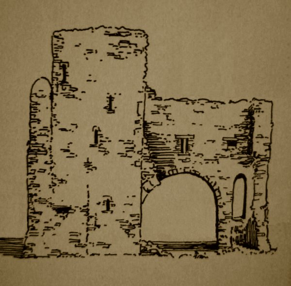
Rathcoffey Castle
Sir John Wogan was a very powerful man at this period. He held the position of Kings Governor of Ireland and had acquired all over Kildare. His successors took up residence in Rathcoffey, and built a new Castle close to or on the site of the previous structure. In 1417 the Gate Tower and Tower House of the castle along with other areas of Rathcoffey are documented in a Wogan dower.6 Other townlands in the area are clearly identified in the dower. They include Clonferth and Baltracey which were leased in various sizes to tenants of Norman extraction for rents of between six pence and fifteen shillings. Evidence of this Norman community in the latter townlands and surrounding areas exists in early field systems. In Baltracey the earlier Celtic ring fort was reconstructed as a rectangular enclosure with double ditch fenced fields leading from it.
The religious centre of the manor was the Church at Balraheen. The parish then known as Barreyn is mentioned in the ecclesiastical taxation of 1303 where the vicarage was valued at forty shillings. The clergyman at the time was supplied by the Knights Hospitalers, a religious order.7
In 1453 an army led by Richard Wogan attacked and captured Rathcoffey Castle from his cousin Anne Eustace (nee Wogan). Anne belonged to a more senior line of Wogans but Richard was the senior male heir. The result of this conflict left Richard in control of Rathcoffey and Anne and her successors the Eustace family possession of the Wogan lands of Clongowes Wood.8
By the 1490 period with the area suffering frequent attacks and in particular from cattle raids by native Irish and earthen boundary wall known as the ‘The Pale’ was constructed through the Wogan lands. Parts of this earthen wall survive to this day. William Wogan as lord of the area would have responsibility for this endeavour.9
In the aftermath of the Reformation all churches including Balraheen were taken over by the Crown and passed on to the newly established reformed Church. The rectory of Balraheen at this time belonged to the hospital of St John of Jerusalem and the tithes amounted to ten and a half coples of corn.10 In 1580 a rebellion in support of the Catholic cause occurred within the Pale and the Lord of Rathcoffey William Wogan, great-grandson of the previous mentioned William, took the side of the rebels. For his part in the failed rebellion he was executed the following year and all his lands forfeited.11
The Wogans soon after regained Rathcoffey but other Lords were gaining townlands in the area. Baltracey became a Eustace possession, the Earl of Kildare acquired Bareen and the greater part of Painstown. With the outbreak of the rebellion and the Civil Wars of the 1640s Nicholas Wogan became involved siding with the rebels. In 1642 the Government sent an army commanded by Colonel Monk to capture Rathcoffey Castle. After a siege the castle surrendered and the garrison were taken to Dublin and executed. Nearly two centuries were to pass before the fate of the civilians within the castle came to light, when numerous human bones were found in a wood close to the castle and were thought to be the remains of those massacred in 1642.12 Nicholas Wogan avoided capture at that time and became a prominent member of the Confederation of Kilkenny.
Following their victory the Cromwellians confiscated the lands of all those implicated in the rebellion. Nicholas Wogan lost his townlands of Rathcoffey, Raheen, Clonfert, and Graiguepottle which at that time included Clonduff. Andrew Aylmer lost his land in Barreen and Painstown while the ownership of Baltracey simply reverted from one Eustace family to another. The lands of the Earl of Kildare at Painstown and Barreen were unaffected.13
A survey carried out in 1654 shows the acreage and letting value of the townlands in the Rathcoffey area prior to the rebellion. Given that the survey was by estimation the townland sizes were not very accurate. However, the average value per acre worked out at seven shillings. Raheen had the highest valuation at ten shillings per acre and Clonfert the lowest at four shillings per acre. The various structures recorded included a waste Corn Mill on the Baltracey River, the Wogan castle and adjoining stone house at Rathcoffey and two other castles at Painstown. One castle had belonged to Andrew Aylmer. It had a valuation of ten pounds sterling and was situated on the same site as the present Painstown Castle. The second castle was on the Earl of Kildare’s land and is not shown on any maps but its most likely site is in the north of the townland in the general area of a disused road that is shown on early ordnance survey maps. Balraheen Church was described as out of repair in 1657 with no ministers. The rectory paid some part of corn worth three pounds to Dublin Castle.14 There was a significant decline in population due to the wars which led to difficulties saving the harvest. A census carried out in 1659 shows the Parish of Balraheen with a population of 159. The only names recorded were two English Cromwellians, William Litchfield in Rathcoffey and Thomas Brooke in Painstown.15
Following the restoration in 1600 the Wogans’ and the Aylmers’ regained their previously held lands and although they supported the Jacobite cause between the 1688–91 period they managed to hold on to their lands in subsequent years. The Wogans’ in particular continued to support the exiled Stuart pretenders and it is thought Col. Nicholas Wogan from Rathcoffey fought with his more famous cousin Sir Charles Wogan from nearby Richardstown in the Jacobite rebellion of 1715.16 This Nicholas was the last Wogan of Rathcoffey. He died without a male heir in 1757 and the Wogan estates were divided between his two daughters Frances who married John Talbot of Malahide and Catherine who married Michael Browne of Castlebrown (Clongowes Wood).
A separate branch of the Aylmers’ emerged in the 17th century. The originator of this branch was Robert Aylmer from Ballycannon who was born in 1610. James Aylmer (1648–1711) was probably the first of this branch to reside at Painstown and by 1718 his son Robert had married Anne Wogan thus linking those two neighbouring families.17 Like the Wogans’ this branch of the Aylmers’ remained Catholics during the penal period.
The penal period saw discriminatory laws against Catholics. Registered Priests were allowed in some parishes on condition that prominent gentlemen went surety for them. Laurence Walsh is listed as Parish Priest of Balraheen and Kilcock in 1704. He was born in 1652 and was ordained in Co. Kilkenny by Dr James Phelan in 1680. His sureties were John Wogan of Rathcoffey Castle and Simon McEvoy of Graiguesallagh. He lived in an isolated farm house at Graiguepottle and administered to his parishioners privately. An old road led from his house to Kilcock.18 There is a Mass rock on this road approximately half way between Graiguepottle and Kilcock which, according to local tradition dates from this time. By 1728 Francis Dillon was P.P. and he officiated from a Mass house in Rathcoffey.19 In the early 18th century the Wogans’ allowed a stable on their estate at Rathcoffey to be used a Mass house. This stable is said to be on the site of the present Rathcoffey Church. Other sources indicate that Lady Tyrconnell, who had connections with the Wogans’ and who frequently visited Rathcoffey Castle, was instrumental in establishing this Mass house in 1710.20 Mass houses were late called Chapels and the one at Rathcoffey was extended and survives as a Church to this day. The Wogans’ and Aylmers’ had private chapels within their castles. A reference to a chapel in Rathcoffey in 1640 probably referrers to the private Wogan chapel within Rathcoffey Castle. The Chapel in Painstown Castle was in existence up to the nineteen fifties.
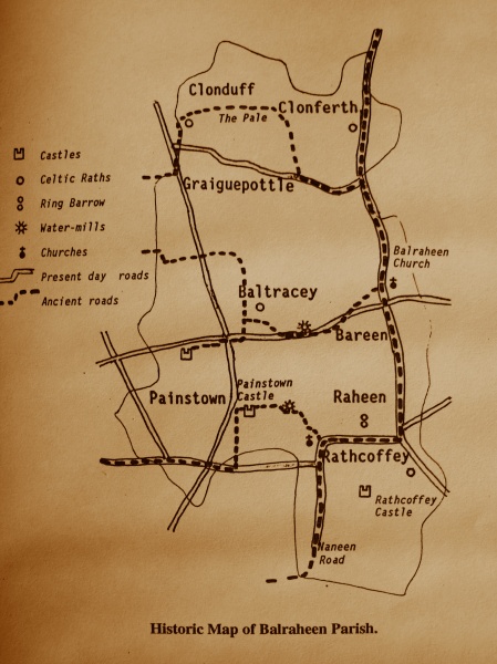
Map showing historic sites in Balraheen Parish
Mass paths emerged at this time as short-cuts to the nearest Church. One such Mass path led from the northern townlands of Balraheen parish and was used by people from the Baltracey Cross area. It led from a style on a bridge on the Donadea to Maynooth road, continued alongside Painstown fox covert then crossed a stream where there were stepping stones for this purpose and further along by a disused mill to the Chapel. Entrance to the Chapel was through a swivel-gate which is still in existence. The distance saved by using this route amounted to one and a quarter miles. This Mass path was later used by Children from the same area as a short cut to their schools and was in regular use until the nineteen forties. Another Mass path extended from Brook Lodge on the Rathcoffey to Straffan road and continued along the two routes to Rathcoffey Castle, exiting at the castle avenue entrance in Rathcoffey village. This route which was used by people from Johninstown and surrounding townlands, was also used by Children as a short cut to the local school.
Maps from the 18th century show Church ruins on the site of Balraheen Church. Three major dwellings are shown in the area. Rathcoffey Castle owned by Richard Wogan Talbot, Charles Aylmer’s dwelling on the site of Painstown Castle and in Baltracey the farmhouse of Mark Eves, situated half a mile east of the corn-mill. The Eves were members of a small Quaker community associated with Baltracey at the time.
The maps show the present road system emerging and also gives sufficient information to identify older roads. The main road at the time appears to be the road leading from Clonfert and Balraheen Church to Rathcoffey. This road then proceeds along the School Road cul-de-sac to Mainham Church. The cul-de-sac has been known from early times as the ‘Naneen’ road and is first mentioned in 1417. ‘Naneen’ is a corruption of An-Annia which seams to come from Eanach or Annagh, the Irish for a marsh or water-place. This would indicate the moorland at Moortown came close to this road and gave it its name. All other roads in the Rathcoffey area branched off this main road. The present Rathcoffey to Painstown road emerged as a route that extended from east to west across two small Drumlins at the edge of an extensive area of moorland. This road is known locally as ‘The Drumin Road’. The name comes from the Irish Druimín which means a small Drumlin. Evidence of a road that extended from Rathcoffey Chapel to Painstown Castle is also shown on early maps. An ancient corn-mill mentioned in medieval documents is sited on this road. The mill was powered by a stream leading from Moortown. A road extended in a westerly direction from Balraheen Church and proceeded to the corn-mill at Baltracey before eventually heading in a north-westerly direction to the Church at Clonshanbo. A branch of this road led to the section of Painstown owned by the Earl of Kildare. One of the oldest known roads in the area extended from Clonfert in a semi-circular direction around Graiguepottle. This road often referred to locally as the ‘ramparts’ emerged from the Pale and could have earlier origins.
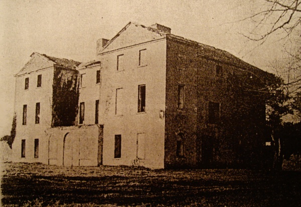
Hamilton Rowan’s House
Archibald Hamilton Rowan a landowner from County Down purchased Rathcoffey Estate from Richard Wogan Talbot in 1785. He built a new mansion on the site of the Castle incorporating the Wogan dwelling in this structure. He took up residence and very soon became involved in left wing politics. He joined the Volunteers, then the United Irishmen and became associated with Wolfe Tone, Napper Tandy and Lord Edward FitzGerald.
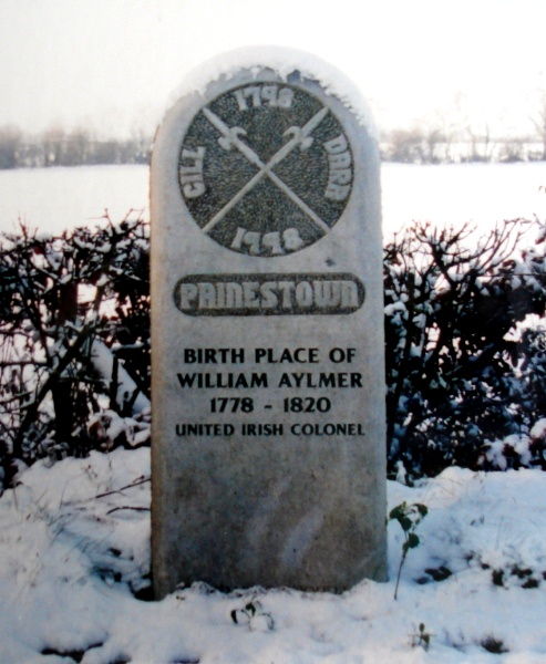
William Aylmer monument
Rowan was arrested in 1794 and sentenced to two years in prison. However, before more serious charges were brought he escaped from prison and eventually made his way out of the country, first to France and then America. Following the outbreak of the 98 Rebellion at Prosperous, William Aylmer from Painstown as one of the highest ranking officers in the United Irishmen to escape arrest took over command of the rebels in the locality. The rebels camped close to Ovidstown Hill where they planned to march on Dublin. However, they were defeated by a better armed force of Government soldiers and Aylmer withdrew his army virtually intact to Timahoe, where they used the surrounding bogland as a refuge. All attempts to dislodge the rebels proved unsuccessful. Aylmer ordered sorties against the enemy and in one of these encounters a band of rebels led by Captain Michael Quigley of Rathcoffey ambushed a unit of Yeomen at the Gollymochy Bridge close to Clongoweswood. With no hope of success Aylmer made contact with the authorities through his father who acted as intermediary. This lead to a peace treaty signed at Rathcoffey. Under the terms Aylmer and the leaders were allowed to go into exile while the rank and file returned to their homes.21
In 1808 an Edward Coonan was appointed to teach in a school built by Parishioners in Rathcoffey. This school was located close to the Chapel. Edward was educated in Kildare Town and came from a family of hedge school teachers. The numbers attending this school gradually increased and by 1824 ninety pupils were on the roll.22 This school-house was later replaced by a two storied building adjacent to the castle avenue.
Two valuations carried out in 1833 and 1854 give an account of holdings within the great estates and list the occupiers.23 The rents of the entire parish of Balraheen was held by eight landowners. John Aylmer from Courtown House was the largest landowner with 1,467 acres. Most of Bareen was held by Archdeacon Johnston while the Hamilton Rowan family held Rathcoffey Estate. Thomas Wogan Browne held the lands of Clonfert North which was originally held by his Wogan ancestors. Gerald Aylmer from Painstown House held part of Painstown together with lands in nearby Belgard. He was a brother of 98 rebel leader and in the 1840’s became active in O’Connell’s repeal movement. He assisted in organising monster rallies and took an active part in the proceedings.24 Baltracey was owned by Samuel Watson from Larchill. This Watson family originally lived at Batracey where they were members of the Quaker community there.
The most numerous dwelling listed in the survey was the three to four roomed mud-walled thatched house which let for average rents of fifteen shillings. Smaller one roomed cabins usually sited on the bank of a ditch had an average rental valuation of five shillings. The rent paid on the average acre amounted to fifteen shillings, the area around Painstown House had the highest valuation at one pound per acre. The biggest slated houses let for three to four pounds upwards.
The Famine did not affect the area to any great extent. However, the decline in population dates from this time. In 1841 the population stood at 475 persons in 82 occupied dwellings. Almost all the people were engaged in farming or agricultural related work. The 1851 census shows a drop in population of 15% with two townlands taking the brunt of the decline. The number of people in Painstown dropped from 128 to 113 with Rathcoffey townland showing a devastating decline of 40% falling from 132 to 81 in 1851. With uncertainty due to the failure of the potato crops and inability of corn crops to pay rents, emigration became the only alternative. Many young people and a significant number of entire families emigrated mainly to America, this not only resulted in depopulation but also an increase in the size of holdings. The population by 1901 had declined buy over a half from 1841 to 213 people in 50 occupied dwellings.
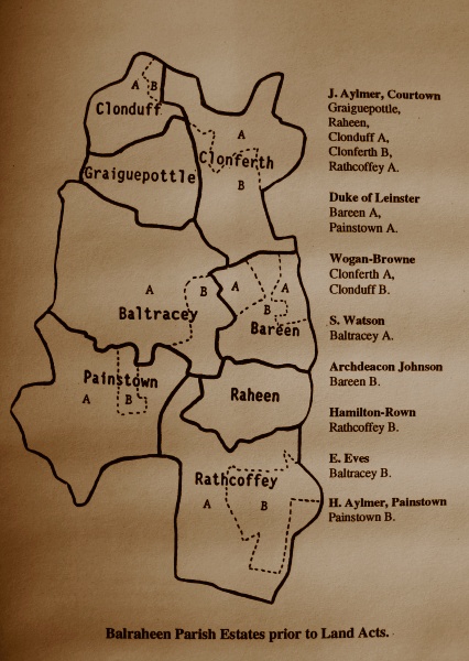
Map showing 19th century estates in Balraheen Parish
The rights won by the tenant farmers in the 1880’s granted them virtual joint ownership of their holdings and following the ‘Land Purchase Act of 1903’ all the landowners with the exception of the Courtown Aylmer’s sold to their tenant occupiers. However, it was not until a further Land Act after Independence that the Courtown Aylmer’s finally sold the last rights to their lands in the area. These events transformed the Rathcoffey area and left 90% of its family’s property owners.
- The Clongowian, 1945, p. 16.
- Fr Shearman, Loca Patriciana, p. 180.
- Anonymous, Back to the Ice Age in JKAS, Vol. XII, p. 422.
- Rev. Matthew Devitt, ‘Rathcoffey’ in JKAS, Vol. III, p. 79.
- A. J. Otway-Ruthven, History of Medieval Ireland, p. 106.
- Rev. Matthew Devitt, ‘Dame Anastasia Wogan’s Dower’, in JKAS, Vol. III, pp 88–97.
- G. E. Hamilton, ‘The Names of the Baronies and Parishes in Co. Kildare’ in JKAS, Vol. IX, p. 255.
- Rev Matthew Devitt, ‘The Barony of Okeaty’ in JKAS, Vol. VIII, pp 480–85.
- Rev. Matthew Devitt, ‘The Rampart of the Pale’, in JKAS, Vol. III, p. 284–89.
- G. E. Hamilton, ‘The Names of the Baronies and Parishes in Co. Kildare’ in JKAS, Vol. VIII, p. 248.
- Devitt, Rathcoffey, p. 81.
- Ibid, p. 83.
- Ibid.
- Robert Simington, The Civil Survey AD 1654–1656, Vol. VIII, County of Kildare.
- Seamus Pender, Census of Ireland Circa 1659.
- Hugh Law, ‘Sir Charles Wogan’, in JRSAI, Vol. LXVII, p. 253–264.
- General Sir Fenton Aylmer, The Aylmer’s of Ireland.
- Rev Michael Comerford, Collections, Diocese of Kildare and Laughlin, Vol. II, p. 165.
- Comerford, Collections, Vol. l, p. 263.
- Details from an article in the Leinster Leader, 1954.
- Fr. Peadar Mac Suibhne, Kildare in ’98, pp 197, 203.
- Martin Brennan, Schools of Kildare and Leighlin.
- See, Tithes Applotments and Griffith Valuation for Balraheen Parish, Co. Kildare.
- Eamon Kane, Danuel O’Connel, Rath of Mullaghmast 1–10–1843.