Seamus Cullen’s Personal Web Site
Featuring Local History from North Kildare
Know your Townland – Mountarmstrong
Published in Le Chéile December 2013
The original name of Mountarmstrong was Birchballagh and the first mention of the townland in documents comes from an Elizabethan Fiant from 1585 when its name was given as Byrtesballagh. It is unclear as to the meaning of the first part of the placename, but one theory suggests that it may have come from a corruption of the Irish Brí which signifies a hill or rising ground. The second part of the placename comes from the Irish word Ballagh which refers to a road or a pass.1 There are many placenames in the country named Ballagh and all relate to ancient roads or passes from the pre-Norman period.
The Mount and its connection to an ancient Boher
Mount Armstrong is on the path of one of the secondary roads of the pre-history period. The principal roads at the time were the five great roads that led from Tara. The secondary roads usually linked the provincial kingdoms. One of the secondary roads in Leinster led from the Kings residence at Nas na Riogh now Naas to Tara and it passed through Mountarmstrong. It is obvious the second part of the townland placename came from this connection. A number of mounds mark the route of this road from the ford at Clane to the principal Leinster—Meath pass at Cloncurry. The mounds are sited at the following locations, at Clane Bridge; Mainham; Mountarmstrong; Donadea and Hortland. Very little is known of the mound at Mountarmstrong, where today a house known as Mount Windsor prominently sits on the summit.
Civil Survey
According to the civil survey of 1654 the townland of Mountarmstrong which was then referred to as ‘Birchballagh’, had an estimated area of 80 acres according to the Irish plantation measurement. This measurement bears little resemblance to the area of the townland at present. An area now included in the townland that adjoined Kilmurry and Kilnamona was marked as woodland. The townland was owned by William FitzGerald of Blackhall, Clane. The survey of Birchballagh estimated that seventy five percent of the townland was arable with the remaining portion divided equally between pasture and shrubbywood. The value of the lands as they were let or worth to be let in the year 1640 was put at £30.2
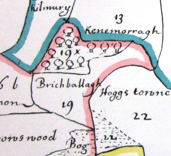
Petty’s Down Survey Map, 1654
The townland passed to James Duke of York later James II under an act of Settlement in 1667. The property passed out of his possession when the Williamite authorities took over in 1691.
Armstrong Family
The modern history of the townland began in 1721 when it was purchased by Charles Armstrong. He was the serving high sheriff of Kildare in that year and he renamed his newly acquired property Mount Armstrong. The Armstrongs came from Stonestown, Co. Offaly and Charles had served as a military officer in the early 1700s. He held Mountarmstrong for ten years until his death between late 1730 and February 1731. Although he had a son who was serving in the army he willed Mountarmstrong to his nephew Edmond Armstrong with a remainder that he should live on the property for at least six calendar months annually. Charles Armstrong’s son Laurence obtained a monetary legacy from his fathers will. This man had an illustrious army career during which he was promoted to the rank of Lieutenant Colonel. In 1725 he served as Lieutenant-Governor of the province of Nova Scotia, Canada and died in 1739.
Edmond Armstrong the new owner of Mountarmstrong also served in leading positions. In 1731 the year he inherited the townland he served as High Sheriff of county Kildare and he died in 1745.3 The fact that Charles Armstrong left a provision in his will for his nephew to live in Mountarmstrong indicated that there was a dwelling suitable for a leading member of the gentry. Members of the gentry who had held the position of High Sheriff of a county usually lived in a substantial country house and it is likely that Charles either built a residence or enlarged an existing house in Mountarmstrong in the 1720s.
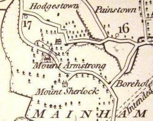
Taylor’s Map, 1783
Two Houses
Cartographic detail from the late 18th century indicate that there were there were two substantial houses in Mountarmstrong, one on the summit of the hill and the other on the site of Mountarmstrong house. This presents a dilemma as to which of the houses was the original house of the Armstrong family. The solution to this may be solved by studying leases connected to new owners of the townland in the mid 18th century. Edmond Armstrong in his will of 1745 directed that agreements relating to Mountarmstrong, that he made with Edward Sherlock, be carried out. This agreement resulted in the ownership of the townland passing to a junior branch of the Sherlock family of Sherlockstown. Noble and Keenan’s Map of 1752 although not entirely to scale, shows a farm house type dwelling on the mount at Mountarmstrong and south of this a more substantial house close to the site of Mountarmstrong house. Taylors Map from 1783 also shows two substantial dwelling houses in much the same location as the previous map. What is interesting is the fact that the house on the mount is referred to as Mount Armstrong and the second house to the south is marked as Mount Sherlock. This could indicates that the house on the mount may have been the original house built by Charles Armstrong or at least the oldest part of it. The second house is likely to have been built by Edward Sherlock. According to architectural experts this house dates from the mid to late 18th century.4 It appears an attempt was made once again to change the name of the townland as it is referred to in some leases from that period as Mount Sherlock. However, this did not succeed and the townland remained Mountarmstrong. The Ordnance Map of 1837 some fifty years after Taylor’s Map shows yet another name change for the two houses. The name Mount Sherlock had disappeared and was replaced by Mountarmstrong House and the original house on the mount was referred to as Mount Windsor. Those names have remained to the present day.
Digby Leasehold
By 1795, the freeholder of the townland was William Sherlock and he let Mountarmstrong House to Rev. John Digby a member of the famous Landenstown family of that name.5 The house was raided by rebels during the 1798 rebellion, and Rev. Digby successfully claimed compensation for losses. Although a clergyman of the established church he was on good terms with clergymen of the Catholic Church and is recorded as letting a house close to Clane in the early 1820s to Fr. Malachy McMahon the local parish priest. Details of a visit to Fr. MacMahon by the famous Bishop of Kildare and Leighlin Dr. John James Doyle in 1823 is recorded as follows:
I came last night to the house of Rev. Mr McMahon, – a splendid mansion, bestowed on him by Dean Digby of the Established Church.6
A search of leases in the general area of Clane reveals that Mountarmstrong was the only property in the possession of Rev. John Digby at this time. So it is likely that Mountarmstrong House was in fact the house referred to in Dr. Doyles visitation to Clane in 1823.
Gerald Aylmer
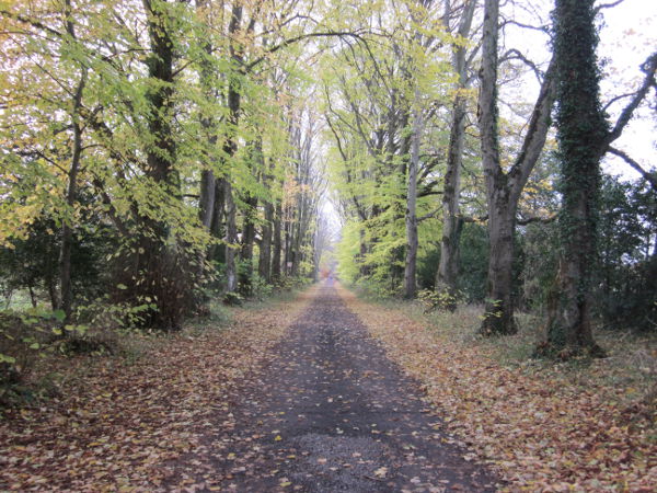
Winter scene in the Mountarmstrong section of the Lime Avenue
In the period following 1854, Gerald George Aylmer of Donadea Castle acquired the leasehold of part of the townland. It appears it was his intention to extend Donadea Demesne to include much of the northern portion of Mountarmstrong and he constructed his grand new entrance into the Castle through this portion of the townland. The entrance came to be known as the ‘Lime Avenue’ and today the section of this avenue in Mountarmstrong is part of Donadea Forest Park.7
Footnotes
- See, P.W. Joyce, The origin of Irish Names and Places.
- Robert Simmington, The Civil Survey AD 1654–56, Vol. VIII, County Kildare (Dublin, 1952), p. 208.
- E.C.R. Armstrong, ‘A note of Charles Armstrong of Mountarmstrong’ in Journal of the Kildare Archaeological Society, Vol. VIII, p. 158; The article indicates that the Digby family were in possession of Mountarmstrong house in 1815.
- Mark Bence Jones, A Guide to Irish Country Houses (London, 1988), p. 212.
- Registry of Deeds, Memorial No. 313334.
- Michael Comerford, Collections, Diocese of Kildare and Leighlin (Dublin, 1883), p. 113.
- According to Sean Flannery of Flannery’s Nurseries Ltd, Staplestown the trees in the Lime Avenue were sowed in two sections. The latter section in Mountarmstrong dates from when the Aylmer family acquired the leasehold.